|
Urban
Economic Sketch Planning Using Complexity Theory
THE
VON THUNEN MODEL - An Example of the Kind of Software
that we intend to develop with the ESRC CASE Award
To
illustrate what we have in mind for the proposed CASA
award, Phil
Steadman's sketch planning model based on the
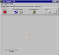
Von Thunen Model can be run from this web site. In essence
what this software does is present the user with a blank
homogeneous landscape on which there is a central market
planted. The user can then use the drawing tools
in the Design mode to add more towns,
transport routes, rail routes, and non-productive land
which act as constraints on the distribution of land
uses. If there are no constraints then the model generates
a symmetical land use pattern around the central town.
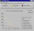
The land use pattern depends on how the transport and
market price lines - bid rent curves in the jargon -
interact with each other. Essentially the von Thunen
model assumes that land use is determined by the market
price less the transport cost and from the interaction
of these bid rent curves, a land use will dominate at
any point a given distance from the town (or from competing
towns). You can also display alter the shape of the
bid rent and cost curve using sliders. You can then
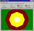
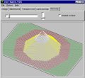
display the land use map and look at the map as a 3-D
surface of rents. You can manipulate this surface using
sliders as well in oblique projection. The various picture
to the right of this screen show you the sequence of
steps from a single town - the red dot in the middle
of the top screen, then just the market rent cost curves,
then the land use map which results, and then the surface
unshaded as contours and then the shaded surface. You
can also import map pictures of real places and run
the von Thunen model with towns and roads etc. planted
on such backcloths. You can access the drop down menus
to do this and you can also change the weights that
way and incorporate a fizzy distance calculations.

Click on this button here to download and run the software
 If
you want to download the data sets and the software,
then click on this button below and this will launch
a self-extracting zip file and enable you to store and
run the program with its full range of inputs from
your desktop.
If
you want to download the data sets and the software,
then click on this button below and this will launch
a self-extracting zip file and enable you to store and
run the program with its full range of inputs from
your desktop.
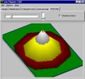
Here
is an example of what you get if you put some roads
into the town and take out some unproductive land from
the landscape
|
|
